
The Netzknoten Navigator connects geographic locations with the formal referencing systems used across the German road network. Users can move from GPS coordinates to road, network node, section, and stationing, or perform the process in reverse. For traffic control contractors, this creates one tool for project preparation, dispatch, field operations, documentation, and downstream data processing.
What kind of product is Netzknoten Navigator?
The product name can initially sound narrower than the actual application.
Netzknoten Navigator is not simply a database for looking up German road network nodes. It is a road-location and referencing application designed for operational work.
A user can begin with a GPS position, coordinates, or a point selected on the map. The application can then determine the available road-network context for that position, including road, network nodes, section, and stationing.
The same workflow also works in reverse.
When a project arrives with a formal road reference instead of coordinates, Netzknoten Navigator can translate that information into a geographic position that can be displayed, shared, and used for navigation.
That relationship between both directions is central to the product. It allows the same road location to move through different stages of a traffic control job without forcing employees to reconstruct it every time they change tools.
Product page: Vextario Netzknoten Navigator
How does the GPS-to-road-reference workflow work?
A field employee may begin with the current GPS position. A project manager may instead have coordinates from a customer spreadsheet. An estimator may simply select a point on the map.
Netzknoten Navigator uses that geographic location to identify the corresponding position in the available road-network data.
Depending on the regional source data, the result can include the road, network nodes, section, and stationing. The underlying model also needs to account for branches, ramps, divided carriageways, and stationing direction when those distinctions exist in the source network.
The result is therefore more useful for specialist road operations than a general statement that a point lies somewhere along a named highway.
Germany does not maintain every relevant road reference in one monolithic state database. The federal trunk road data set published through the Federal Highway Research Institute is derived from the road information databases of all 16 German states.
For a nationwide product, handling regional road-network structures is therefore a core part of the job rather than an edge case.
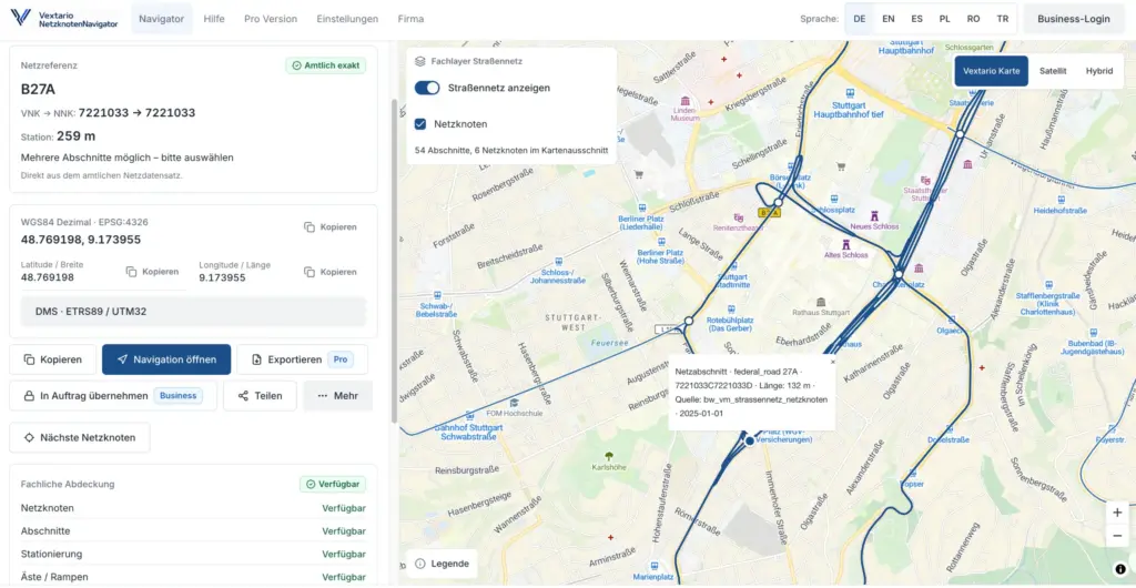
Can Netzknoten Navigator convert a road reference back into a real location?
Yes, and this is one of the product’s most important functions.
Many map applications can display latitude and longitude. Traffic control contractors, however, often receive project information in another form: road designation, network section, node references, stationing, or a combination of those values.
Netzknoten Navigator supports bidirectional road referencing.
A formal road reference can be resolved back into geographic coordinates and displayed on the map. That creates a useful bridge between road-authority documentation and field operations.
For project preparation, a stationing value becomes a location that can be inspected visually.
For field employees, the same result becomes a point that can be opened on a phone and transferred to navigation.
For reporting and data processing, the formal road reference remains available alongside the geographic position.
Which coordinate formats does the product support?
Road authorities, GIS applications, smartphones, planning documents, and contractors do not always use the same representation of coordinates.
Netzknoten Navigator therefore provides several views of the same location.
Users can work with WGS84 decimal coordinates, degrees-minutes-seconds, and ETRS89/UTM Zone 32. This avoids the common situation in which an employee has already found the correct site but still needs a second website or desktop application solely to convert the coordinates.
ETRS89 is a standard geodetic reference framework used for official geospatial work in Germany. The German Federal Agency for Cartography and Geodesy maintains registry information for ETRS89 coordinate reference systems and their use in national geospatial services.
In practice, that means a GPS location received from a phone can be represented in a format suitable for another professional workflow without restarting the search.
What does the user actually see on the map?
The map is not merely a backdrop for a pin.
Netzknoten Navigator combines geographic orientation with available road-network information. Network nodes, road sections, and related road context can be displayed together with the selected location.
Users can switch between regular map, satellite, and hybrid views. That is helpful when a work site needs to be evaluated not only in relation to the road centerline but also to visible surroundings, access points, structures, and terrain.
A user’s current GPS position can be displayed together with the resolved road reference. Office employees can instead select another region or point without relying on the computer’s physical location.
The relevant German state can be detected from the chosen point, while manual state selection supports planning and research in another region.
That regional awareness matters because road-network data is maintained differently across Germany.
Saxony, for example, publishes derived road stationing data at one-meter intervals through its official road information data infrastructure.
A nationwide application has to work with those regional capabilities without expecting users to understand the source architecture first.
How is Netzknoten Navigator different from a normal mapping app?
| Task | General mapping app | Netzknoten Navigator |
|---|---|---|
| Search for an address | excellent | secondary use case |
| Display GPS position | yes | yes |
| Display coordinates | yes | yes |
| Determine German road network nodes | generally no | yes, where supported by source data |
| Determine road section and stationing | generally no | yes |
| Resolve a road reference back to coordinates | generally no | yes |
| Handle stationing direction | no specialist model | yes |
| Handle multiple plausible network matches | not designed for this | part of the road-reference workflow |
| Show source and data vintage | usually limited | part of the result context |
| Process CSV batches | no | professional feature |
| Export GeoJSON | usually no | yes |
| Support specialist OKSTRA workflows | no | supported for suitable data environments |
| Provide road-reference API functions | generic maps API | specialist road-network API |
| Provide MCP road-network tools | no German network domain layer | planned product capability |
A consumer mapping application mainly answers the question, “Where is this place?”
Netzknoten Navigator adds another question: “How is this place represented in the professional road network, and how can that reference move into the next operational step?”
Those are related tasks, but they are not the same task.
How can users find network nodes directly from the map?
Not every job starts with a complete coordinate or an existing station reference.
Sometimes an employee only knows the approximate location of a planned work zone. In that case, a point can be selected on the map and nearby network nodes can be examined together with the relevant road context.
This is useful when customer documents contain a road designation but the exact network relationship still needs to be identified.
The application is not limited to a simplistic “nearest node” calculation. Around interchanges, branches, and divided roads, the physically nearest node may not automatically be the best professional reference for the selected point.
Road sections, branches, direction information, and the course of the network can therefore become part of the evaluation.
The goal is not to show a node number in isolation. It is to connect the physical location with a usable road-network relationship.
Why does the product include bridge and structure search?
Road structures often become natural reference points in traffic control projects.
A temporary traffic control layout may begin near a bridge. A road authority may identify the project through an official structure number. An inspection route may involve a specific engineering structure, while the field crew ultimately needs to know where that structure sits on the road.
Netzknoten Navigator therefore includes structure-related search capabilities where source data supports them.
Users can search for road structures using official identifiers and connect the structure with its surrounding road reference. Structures near a selected road position can also provide useful operational context.
For a contractor, this reduces the need to search one system for the structure, another for the road section, and a third for the geographic position.
How can project preparation send the exact same result to the field crew?
Sharing is one of the less technical features, but it can remove a surprising amount of repeated work.
A planner may identify the site on a desktop. Without a shared digital reference, the next step often involves sending a screenshot, copying coordinates into a message, or describing the location in text.
The recipient then performs another search on a phone.
Netzknoten Navigator can generate a persistent link to the resolved road location. The recipient opens the same result rather than recreating it.
QR codes provide another handoff option. They can be added to a work order, printed document, project sheet, or internal instruction.
A human-readable road reference can also be copied into email, project documentation, customer communication, or another company system.
The same concept works in reverse. A field employee can identify a position and send the result back to project management or dispatch.
Can the resolved position be sent directly to navigation?
Yes.
The field employee should not have to manually translate a professional road reference back into coordinates before driving to the site.
Once Netzknoten Navigator has resolved the location, the geographic target can be transferred to supported navigation services or the device’s system navigation.
The road reference remains the professional description of the site. The navigation application receives the geographic point it needs.
This distinction is particularly useful outside built-up areas.
A section and station can be appropriate for authority documents, project records, and communication with road professionals. A navigation system, however, needs a physical destination.
Netzknoten Navigator connects both representations.
How does Netzknoten Navigator handle imperfect road data?
No road-network data set is permanently complete.
Roads are rebuilt, classifications change, interchanges are modified, and state systems expose different attributes. A nationwide interface cannot simply pretend that every region provides identical information.
Netzknoten Navigator therefore treats source, data vintage, and regional capabilities as meaningful parts of the result.
When several road-network assignments are plausible, the application can expose that situation instead of forcing an arbitrary single match.
This can matter around ramps, complex junctions, branches, and closely spaced carriageways.
The same principle applies to missing data. If reliable stationing or another specialist attribute is not available from the underlying regional data, the application should not generate a substitute value merely to complete the display.
For traffic control operations, this behavior is important because a convenient answer is not useful if the underlying road relationship cannot be supported.
What happens when a field employee discovers a data problem?
People working on roads eventually encounter situations where the digital representation does not match what they expect from the site or project documentation.
Netzknoten Navigator includes a structured feedback workflow for that situation.
A user can report a suspected issue with the road, section, stationing, direction, or another part of the resolved result.
The feedback does not automatically overwrite the source road data.
That distinction matters because an observation from the field is valuable evidence, but it is not automatically an official network update. The issue may come from outdated source data, a regional data gap, an unusual network configuration, or the resolution logic itself.
A separate review process can determine what actually needs to be corrected.
How does the product work on smartphones and tablets?
Netzknoten Navigator is a responsive web application designed for desktop, tablet, and smartphone use.
The mobile experience is not intended to be a full desktop GIS interface squeezed onto a smaller screen. Common field actions are designed around short interaction paths and touch-friendly controls.
On supported devices, the application can also be installed as a progressive web app.
GPS can be used when location access is available, but the product does not depend on GPS permission for every workflow. Users can still enter coordinates, select a point on the map, or resolve an existing road reference.
The interface supports German, English, Spanish, Turkish, Polish, and Romanian. For traffic control contractors with multilingual field teams, language support can make a specialist tool considerably easier to deploy across the workforce.
How can a company process many road locations at once?
Single-location search is only part of the problem for contractors handling larger projects.
Framework contracts, customer spreadsheets, inspection programs, and multi-site projects can contain long lists of locations.
Professional Netzknoten Navigator workflows therefore include CSV batch processing.
A company can upload a list of geographic coordinates and resolve them into road-network references. The opposite workflow is also supported, allowing road references to be converted into geographic locations for downstream systems.
Column mapping helps adapt different customer or internal spreadsheet formats.
A bad row should not require the entire batch to be discarded. Exceptions can be identified separately while successful records continue through the process.
That turns road referencing from an individual lookup into a repeatable operational data workflow.
Which export formats are available?
A resolved location often needs to leave the application.
CSV supports spreadsheets, reporting, business intelligence, and many traditional business systems. GeoJSON provides a practical format for GIS and web-mapping environments.
For suitable professional data environments, Netzknoten Navigator also supports an OKSTRA-oriented export workflow with schema validation.
Export is not limited to the bare geographic point.
Source provenance, data vintage, confidence information, and assignment status can also be carried into downstream processing where appropriate.
This is important because a coordinate alone does not explain how the road reference was determined or which underlying road-network state was used.
For project records and system integrations, that context can be as useful as the location itself.
How can existing company software use Netzknoten Navigator?
A traffic control contractor should not have to recreate German road-reference logic independently in every application.
The professional product therefore includes a Road Network Intelligence API.
Connected systems can use specialist functions to resolve coordinates into road references, translate stationing back into geographic positions, retrieve network context, and determine which capabilities are available for a region.
Potential users include customer portals, dispatch applications, inspection software, GIS workflows, project systems, and internal operational tools.
The employee does not necessarily have to leave the company’s existing application. The road-location capability can be called where the workflow already takes place.
This reduces duplicated implementation and helps different applications use the same interpretation of a road location.
What is the purpose of the MCP integration?
MCP extends the same road-network capability to compatible assistant systems.
A general language model may understand the words road, GPS, or bridge, but it does not automatically possess a current professional mapping between a coordinate and the relevant German network section.
Vextario’s MCP approach allows the assistant to call dedicated functions instead.
These can include finding a network node, locating a road section, resolving a geographic position, resolving stationing, and retrieving road-network context.
The assistant therefore does not need to invent a road reference from general knowledge.
For contractors, the longer-term value is that the same specialist road-network capability can support conventional software, mobile applications, automation, and assistant-driven workflows.
Which functions can be used without a business account?
The product is designed to allow users to start with the core workflow without first implementing an enterprise software project.
Basic road-location functions can be used without registration. These include the central search and referencing workflow, coordinate representations, sharing, and navigation handoff.
Business functionality becomes relevant when the application moves from occasional individual use into a company process.
That includes higher usage levels, organization and team administration, cloud-based favorites, shared project context, batch processing, exports, API access, and integration capabilities.
A small contractor can therefore begin with direct interactive use, while a larger organization can expand the same product into structured operational workflows.
Which companies benefit most from Netzknoten Navigator?
The strongest use case appears when road locations repeatedly move between people and systems.
Traffic control contractors with several crews, framework contracts, inspection routes, work on classified roads, or projects across several German states regularly encounter that problem.
The product can also be useful when customer spreadsheets, tender documents, authority references, internal project systems, and field applications all describe locations differently.
A small company may primarily use the map, road-reference lookup, sharing, and navigation.
A larger organization can add batch processing, exports, project context, and integration.
The product therefore scales from individual road-location work to structured data processing without requiring the company to introduce a traditional enterprise GIS solely for stationing.
Additional applications for traffic control contractors, field operations, and road-related workflows are available through the Vextario traffic control product family.
Why is Netzknoten Navigator more than a network-node search tool?
Because the actual value lies in the transitions between the individual functions.
GPS becomes a road reference. A station becomes a map position. The map provides context. A link moves the location to a crew. Navigation turns it into a destination. Batch processing handles project lists. GeoJSON moves the result into GIS. An API exposes the same road-location logic to another application.
The network node is an important part of the underlying model, but it is not the entire product.
Netzknoten Navigator treats a road location as operational information that needs to survive multiple representations during the life of a project.
That is what separates it from a state road map, a coordinate converter, or a consumer navigation application.
Companies can explore the product directly on the Vextario Netzknoten Navigator product page.
Manufacturer: KrambergAI GmbH
https://krambergai.com/
Sources for the statistics used
Federal Highway Research Institute via GovData: Federal Trunk Road Network Dataset
The nationwide data set is derived from the road information databases of Germany’s 16 states.
https://www.govdata.de/suche/daten/datensatz-bundesfernstrassennetz
GovData / LISt GmbH on behalf of the Saxony State Office for Road Construction and Transport: Road Network Stationing Dataset
The Saxony data set contains derived stationing positions at one-meter intervals.
https://www.govdata.de/suche/daten/gdi-sbv-stationierung-strassennetz-ds40b4b
Further reading
Lower Saxony State Authority for Road Construction and Transport: Road station signs and the stationing system
https://www.strassenbau.niedersachsen.de/startseite/aufgaben/strassenunterhaltung_und_strassenbetrieb/stationszeichen/stationszeichen-78417.html
Federal Agency for Cartography and Geodesy: ETRS89 coordinate reference system registry
https://sg.geodatenzentrum.de/web_registry/crs-gdz/coordinateReferenceSystem/GEO_ETRS89.html
Straßen.NRW: NWSIB-online user manual
https://www.strassen.nrw.de/files/a_snrw-2022/dokumente/01_planen-und-bauen/08_Infos-Umsetzungspartner/06_NWSIB/Das-Projekt/Anwenderhandbuch%20NWSIB-online%20Internetversion.pdf
Frequently asked questions
Can Netzknoten Navigator determine my current road location?
Yes. On a device with location permission, the current GPS position can be used as the starting point. Netzknoten Navigator can then associate the position with the available road network. Users who do not grant GPS access, or who are preparing a different site, can enter coordinates, select a map point, or start from an existing road reference instead.
What information can the product return for a road location?
Depending on the available regional source data, the result can include road, network nodes, section, stationing, stationing direction, travel direction, and geographic coordinates. Information about source, data vintage, and assignment quality can also accompany the result. Attributes that cannot be supported by the regional data are not simply manufactured to complete the display.
Can I display a road section and station directly on the map?
Yes. The road-reference workflow is bidirectional. If a tender or road-authority document contains a road, section, and station value, Netzknoten Navigator can resolve that information into a geographic point. The result can then be reviewed on the map, shared with another employee, or transferred to navigation for the trip to the actual work site.
Does Netzknoten Navigator support UTM coordinates?
Yes. In addition to WGS84 decimal coordinates and degrees-minutes-seconds, the application supports ETRS89/UTM Zone 32. This allows the same physical position to be represented in several common professional formats. A GPS coordinate from a phone can therefore be reused in GIS, planning documents, project records, or customer workflows that require UTM coordinates.
Can I share a location with somebody who does not have an account?
The sharing workflow is designed for straightforward operational handoffs. A result can be sent through a persistent link or QR code, so the recipient does not need to retype the road reference or coordinates. This is particularly useful when information moves between project preparation, dispatch, supervisors, field crews, subcontractors, and other project participants.
What happens when several road sections are plausible?
Complex junctions, ramps, branches, and parallel carriageways can produce situations where more than one road-network assignment is technically plausible. Netzknoten Navigator is designed to expose that situation rather than silently forcing an arbitrary match. Available alternatives and road context allow the employee to review which reference is appropriate for the actual operational task.
Can the application process large Excel or CSV lists?
Professional workflows include CSV batch processing. Companies can process lists of coordinates into road references or perform the reverse transformation from road references into geographic positions. Column mapping supports different spreadsheet structures. Individual records that cannot be processed reliably can be separated for review without automatically invalidating every successfully processed row in the same batch.
Which data formats can be exported?
Professional features include CSV and GeoJSON output, along with OKSTRA-oriented export for suitable data environments. These formats allow road-location results to move into spreadsheets, GIS platforms, specialist applications, and downstream workflows. Source provenance, data vintage, and assignment status can also accompany the location data when that context is relevant to subsequent processing.
Is Netzknoten Navigator intended only for desktop users?
No. The application is designed for desktop computers, tablets, and smartphones and can be installed as a progressive web app on supported devices. A location can therefore be prepared in the office and later opened in the field. GPS, map interaction, sharing, and navigation handoff support mobile work without requiring a full desktop GIS workstation.
Can Netzknoten Navigator integrate with our existing software?
Yes. Professional functionality includes a versioned Road Network Intelligence API and MCP capabilities. Other applications can use these services to resolve coordinates, translate stationing into geographic positions, and retrieve road-network context. Companies therefore do not need to independently implement and maintain German Netzknoten, section, stationing, and regional data logic in every internal system.
