
A WFS service can deliver georeferenced road data, but it is not yet an operational product for temporary traffic control companies. Import, normalization, quality assurance, versioning, and a dedicated access layer are what make network nodes, road sections, and stationing dependable in daily work. Netzknoten Navigator sits precisely between the authoritative source and the field-facing application.
A dispatcher preparing a lane closure, a project manager reviewing a traffic order, or a crew lead trying to locate a work zone is rarely thinking about FeatureTypes, XML schemas, or coordinate reference systems. The practical questions are different: Which network nodes define the road section? Which stationing reference belongs to the work site? Is the selected point really on the intended carriageway section? Can that reference move into the order, permit workflow, work package, and documentation without another round of manual interpretation?
That gap between published geospatial data and day-to-day use is where product engineering starts. A Web Feature Service, or WFS, is highly useful as an exchange mechanism. It was not designed, however, around the workflow of a German traffic safety contractor who needs to locate a classified road section, verify the relevant Netzknoten, copy the network reference, and continue working without opening several state portals.
Why is a WFS service not yet an operational application?
The Web Feature Service standard maintained by the Open Geospatial Consortium (OGC, https://www.ogc.org/) defines standardized access to geographic features and their properties. It covers 11 operations, including discovery of service capabilities, description of feature types, and retrieval of individual or filtered features. That is a powerful technical foundation, but it does not represent the workflow of a temporary traffic control business.
A WFS may expose road sections, Netzknoten, zero points, stationing data, or other objects. The standard does not determine whether field names make sense to an estimator or dispatcher, whether relationships between nodes and sections are complete, whether geometries line up as expected, or whether the service responds quickly enough while a customer is on the phone.
A production system therefore needs another layer. That layer translates each source into a stable internal model, records provenance, tracks the import state, applies data-quality rules, and decides which version is permitted to reach end users. The source remains authoritative for what it publishes; the application takes responsibility for turning the published material into a controlled operational dataset.
Where does a dependable import process actually begin?
A robust importer should not start by requesting every available feature and hoping for the best. It first inspects what the service offers: layers, attribute definitions, geometry types, coordinate reference systems, filters, paging behavior, response limits, and implementation-specific quirks.
Paging deserves special attention. Large WFS layers are often delivered in chunks rather than in one response. The importer has to request those pages in a reproducible order, merge them, and verify that nothing was skipped or duplicated. A successful HTTP response only proves that a request was answered. It does not prove that the dataset was imported completely. GeoServer documentation, for example, describes paging through startIndex and count for WFS requests.
There is also value in retaining raw responses, source snapshots, or equivalent reproducible import artifacts. When a discrepancy appears later, the team can determine whether it already existed in the public source or was introduced during transformation. For traffic control work, that lineage matters because a road-network reference may end up in a traffic order application, a work-zone plan, an internal job packet, a customer handoff, or later evidence of how the location was determined.
Another practical lesson is that importers should expect change. Agencies can rename fields, replace identifiers, alter output defaults, or publish additional layers without coordinating with every downstream user. The importer therefore needs explicit contracts and failure states instead of quietly accepting any technically valid response.
Why do road-network datasets need normalization?
Germany does not expose one nationwide WFS schema in which every state models Netzknoten, sections, branches, road classes, and stationing in exactly the same way. Attribute names differ, identifiers differ, and the way relationships are represented can differ as well. Even where the underlying road-reference concepts are comparable, the delivery model may not be.
A production platform cannot push these differences all the way into the frontend. Otherwise, the search form, map logic, filters, and result cards would need state-specific branches everywhere. Normalization converts diverse source structures into common domain objects such as roads, network nodes, sections, branches, stationing references, and source metadata.
That transformation must be conservative. Missing network nodes should not be invented. Conflicting sections should not be silently repaired because a basemap suggests what they probably should look like. A road name should not be added merely because another dataset contains a plausible label. The goal is not to maximize the number of records. The goal is to preserve source meaning while making the data consistently usable.
This is especially important for mid-sized traffic control companies because operational staff should not have to understand how each German state decided to encode the same category of road information. The system should absorb that technical variation once, centrally, rather than making every user compensate for it repeatedly.
What does QA mean for network nodes, sections, and stationing in practice?
Quality assurance starts where schema validation stops. A geometry can be technically valid and still be wrong for the active road network. A section can exist but point to a missing node. A stationing value can be syntactically acceptable while conflicting with the length or direction of the associated section.
Useful QA therefore tests both geometry and domain relationships. It asks whether nodes connect to the expected sections, whether section geometries reach their expected endpoints, whether road-class references exist, whether objects fall inside the expected administrative territory, whether stationing follows the source model, and whether duplicate or orphaned records have appeared.
A common failure pattern is the feature that looks perfectly normal in isolation but should not enter the production set. Another is a source update that changes only a key while the geometry and semantics remain the same. Without a comparison against the previous release, the system may interpret that as one deletion plus one new object, even though the road feature itself did not materially change.
For that reason, a production pipeline benefits from hard release gates: required fields present, geometry valid, key relationships intact, spatial placement plausible, provenance recorded, and source status known. Records that fail should move into a review queue rather than into the live search index. This makes the data lifecycle slower at the ingestion boundary and faster everywhere else.
Why does a production geodata layer need versioning?
Road networks change. Nodes are added, road sections are rebuilt, classifications change, junctions are remodeled, and source data is corrected. If every import simply overwrites yesterday’s state, it becomes difficult to explain why a network reference used in a previous job no longer resolves in the same way.
Versioning turns each source refresh into a controlled release. An import receives a source timestamp or snapshot reference. The incoming dataset is compared with the currently active version. New, removed, and changed features can then be evaluated separately rather than mixed into one opaque replacement operation.
This also creates operational resilience. A problematic source update does not have to reach every user immediately. The new version remains inactive until ingestion and QA are complete. If an issue appears after activation, the service can revert to the previous approved dataset while the source or transformation problem is investigated.
For work-zone operations, that historical context can become valuable months later. A team reviewing an old traffic order or customer dispute may need to understand what road reference was available at the time of the job, not what the source looks like today.
Why should the frontend avoid querying an agency WFS directly?
The shortest architecture is tempting: browser request, WFS response, draw feature on the map. That approach can be acceptable for a proof of concept. It creates unnecessary operational dependencies in a product that people expect to work throughout the business day.
An agency endpoint can be in maintenance, respond slowly to large filters, enforce changing limits, modify its schema, or return formats that behave differently across implementations. Browser security rules, network interruptions, and varying response times add another layer of risk. With a direct integration, every one of those conditions is immediately visible to the user.
A dedicated data layer changes the relationship. The WFS becomes an input channel rather than a runtime dependency for every click. The frontend operates against an approved dataset with an application-owned schema. Source attribution and provenance remain available, while the user experience no longer depends on the current health of an external service.
This is not about treating official data as secondary. It is about separating two responsibilities: the agency publishes its data, and the product prepares that data for a specific operational workflow.
What does caching add when the data is already stored in a database?
A database and a cache solve different problems. The database maintains the approved road network and its relationships. The cache reduces the cost of repeated responses, including searches for road numbers, common map extents, frequently accessed Netzknoten, and spatial lookups around known locations.
Interactive maps can produce many near-identical requests as a user pans, zooms, changes a filter, or reopens the same job. Running a full spatial query for every movement is wasteful. Cached results can be keyed by region, map extent, filter set, and active data version so that common requests are served with far less database work.
The important design requirement is version awareness. A cache cannot be allowed to outlive the dataset it represents. One practical pattern is to include the active data-version identifier in the cache key. When a new network release becomes active, old cache entries automatically fall outside the active request path without requiring fragile manual cleanup rules.
Caching can also protect the API from bursts of identical requests. In a traffic control office, several people may work on the same road corridor or revisit the same project area during planning. Reusing those results is both faster for the user and more economical for the platform.
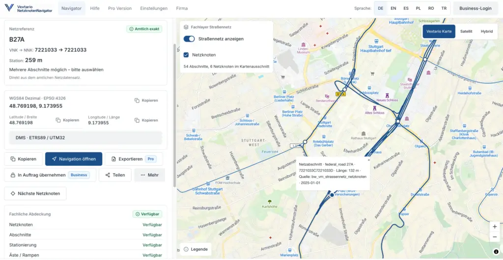
How does geospatial data become an API designed for traffic control work?
A useful domain API should not simply reproduce the WFS schema. It should expose tasks. Instead of forcing the client to construct a generic feature query, the API can support operations such as finding network nodes for a road, resolving the nearest section to a coordinate, identifying the section between two nodes, determining stationing for a selected point, or returning the provenance of a result.
Spatial indexing is important here. PostGIS recommends GiST indexes for geometry columns so that spatial predicates can use an index rather than scan the complete dataset. For a production product, that distinction matters because users expect map and location searches to respond as part of an ordinary workflow, not as batch GIS jobs.
The API layer is also where access control, rate limits, error semantics, and plan entitlements belong. A free public search may expose a limited set of calls, while authenticated business workflows can receive richer context or higher request volumes. Internal QA fields can stay private, while source, version, and verification metadata remain available where operational review requires them.
A well-designed API also makes future clients easier to build. The same backend can support the web application, an installable PWA, internal dispatch tools, integrations with Vextario modules, and later machine-to-machine access without duplicating the state-specific geodata logic in every client.
How should the frontend translate road data into a real workflow?
The user should not need to know which WFS layer originally contained a Netzknoten. The interaction should start with road, place, network node, or map position. The system then presents the relevant domain objects, lets the user inspect the surrounding road network, and makes the resulting network reference easy to transfer into the next business step.
That is the role of Vextario Netzknoten Navigator at https://netzknoten-navigator.vextario.com/: it turns road-network references into something dispatchers, project managers, estimators, and field staff can use without manually navigating state-specific data services.
For a German traffic safety contractor, this translation is the part that creates value. A FeatureType can be modeled perfectly and still save no time. What matters is whether the crew or office team can find the intended section, verify the reference, and continue with order intake, traffic-order preparation, dispatch, documentation, or customer communication with less retyping.
The same principle extends into the broader Vextario product portfolio at https://vextario.com/. Road-network data becomes more valuable when the selected reference can later flow into operational modules instead of remaining isolated inside a map tool.
What usually goes wrong in pipelines like this?
Coordinate handling is a frequent source of failure. A service can return geometries in a different coordinate reference system or axis order than the consuming code expects. A feature may then appear far from its real location even though every number parsed successfully. GeoJSON, by contrast, uses WGS 84 longitude and latitude in decimal degrees under the relevant IETF standard, so transformations between WFS, database storage, API output, and browser rendering need deliberate rules.
Other failures are less visible. Paging may stop before the full source has been read. A provider may rename an attribute. A supposedly permanent identifier may change. Two geometrically identical features may carry different domain keys. An application cache may continue returning old records after a release. A health check may verify that records exist while never testing whether the network relationships still make sense.
Another common mistake is tying frontend components directly to source-specific field names. That works until the first source changes. When normalization and API contracts are missing, a small upstream adjustment becomes a frontend incident.
The most dangerous outcome is a pipeline that reports success because every technical step completed. In operational geodata, “import completed” should mean only that the source material has arrived. Promotion to production should happen only after the data has passed the release gates relevant to the use case.
How do raw WFS access, a production data layer, and Netzknoten Navigator differ?
The comparison below shows why several controlled processing stages belong between the source service and the interface used by a traffic control company.
| Area | Direct WFS access | Production geodata layer | Netzknoten Navigator |
|---|---|---|---|
| Data model | Source-specific feature types | Normalized road-domain objects | Reduced to search and operational tasks |
| Availability | Depends on the external endpoint | Uses an application-owned approved dataset | Reads from the controlled product layer |
| Quality assurance | Limited to what the publisher validates for publication | Adds import, relationship, geometry, and release checks | Presents only approved objects |
| Versioning | Varies by source | Snapshots, diffs, release state, rollback | Users work against a defined active release |
| Performance | Depends on source response behavior | Spatial indexes, prepared queries, application caching | Fast search, map interaction, and contextual lookups |
| Business workflow | Generic geospatial features | Roads, nodes, sections, branches, and stationing | Selection, verification, copying, and handoff into operations |
The extra architecture is not there to make geodata look more sophisticated. It prevents every source-specific technical decision from leaking into the daily work of the customer.
Why does this data pipeline matter economically to a traffic control company?
Germany’s federal trunk-road network totals about 50,956 kilometers of federal highways and federal roads. That gives a sense of the scale at which road information is already being maintained before state, county, municipal, and other operational layers are considered. For a contractor, however, the problem is not the total length of the network. The problem is finding the one correct reference for the job in front of the team.
State data shows how detailed the source material can become. Brandenburg’s current classified-road download service includes Netzknoten, road-network data, and stationing information down to a 5-meter interval, and its dataset is updated quarterly. That level of detail is useful, but it also illustrates why ingestion and versioning matter: every source refresh has to enter the product in a controlled way without turning an upstream change into a disruption for office or field users.
For a mid-sized company, the savings are usually scattered across many small actions rather than one dramatic automation: less portal switching, fewer copied identifiers, fewer searches repeated by different employees, less dependence on the one colleague who knows where a state stores its network data, and a better chance that the same reference survives from intake through execution.
The Netzknoten Navigator at https://netzknoten-navigator.vextario.com/ can be used directly as the focused entry point for this workflow. It is part of the Vextario portfolio at https://vextario.com/ for traffic safety and temporary traffic control companies, where related products are designed around order intake, dispatch, documentation, and operational coordination. Vextario is developed by KrambergAI GmbH, https://krambergai.com/.
Which sources support the quantitative figures used above?
Open Geospatial Consortium: WFS Standard — 11 defined operations.
URL: https://www.ogc.org/standards/wfs/
German Federal Ministry of Transport: Road construction and expansion — federal highways and federal roads total approximately 50,956 kilometers.
URL: https://www.bmv.de/SharedDocs/DE/Artikel/StB/aus-und-neubau-von-strassen.html
GovData / Brandenburg State Road Authority: Classified Road Network Brandenburg — quarterly updates and stationing data down to 5 meters.
URL: https://www.govdata.de/suche/daten/klassifiziertes-strassennetz-brandenburg-autobahnkilometrierung371ba?ids=0485eab7-f338-4bb4-b3ea-098d01b1bdf1
Which links are useful for further reading?
Further reading
IETF / RFC Editor: The GeoJSON Format
https://www.rfc-editor.org/rfc/rfc7946.html
PostGIS: How do I use spatial indexes?
https://postgis.net/documentation/faq/spatial-indexes/
European Commission – INSPIRE: Technical Guidance for the implementation of INSPIRE Download Services
https://inspire-mif.github.io/technical-guidelines/services/download-atom-wfs/DownloadServices.html
What is a WFS service?
A Web Feature Service exposes geographic features and their attributes through a standardized interface. Unlike a map image service, it can provide the underlying objects that a client can query and process. In road-network applications, those objects may include sections, network nodes, or stationing references. Production use still requires transformation, quality controls, version management, and an application-specific domain model.
Why are Netzknoten relevant to traffic control companies?
Netzknoten provide a structured way to reference sections of the classified German road network. That becomes useful when a work zone, traffic order, or field location cannot be described adequately by a street address alone. A shared network reference can improve coordination among the customer, dispatcher, project manager, field crew, and public authority, provided they are working from compatible road-network data.
What does stationing mean in a road network?
Stationing describes a position along a defined road section. Instead of storing only a point on a map, the location is related to a section and a distance along that section. In road administration and work-zone operations, this provides a domain-specific location reference that can be used in planning, documentation, and communication when ordinary street addresses are insufficient or ambiguous.
Why is a map view alone not enough?
A map is useful for visual inspection, but it does not replace a structured road-network reference. Two points can appear close together while belonging to different sections, carriageways, directions, or branches. A production application therefore combines cartographic context with road, node, section, and stationing data so that the user can both inspect the location and transfer the appropriate reference into the next workflow.
Can an application use an agency WFS directly in the browser?
Yes, and direct access is often useful during prototyping or source analysis. For ongoing operations, it creates dependencies on the external service’s response time, availability, schema, browser-access policy, and output behavior. An application-owned data layer reduces those dependencies. The official endpoint remains the source, while the product serves an approved and versioned dataset that is optimized for the customer’s workflow.
How can a system prevent outdated network data from being displayed?
The core mechanism is a controlled release process combining import, comparison, QA, activation, and cache invalidation. A newly downloaded source should not automatically replace the active dataset. It is first compared with the previous release and checked for structural or domain problems. Only then is it promoted. Caches should reference the active version so responses from an earlier release cannot remain in circulation after activation.
What happens if source identifiers or attributes change?
The importer should detect those changes rather than letting them propagate unpredictably. External fields are mapped into internal domain fields, and schema changes are monitored as explicit events. When an identifier changes, the pipeline must determine whether a genuinely new road object was created or whether the source simply reassigned the key of an existing one. That distinction is important for history, deduplication, and downstream references.
What role does the API play between the database and frontend?
The API isolates internal storage from the user interface and exposes task-oriented functions. The frontend can ask for network nodes on a road, a section near a map coordinate, or provenance for a result without knowing table layouts or state-specific source fields. The same layer can enforce permissions, request limits, version selection, and consistent error behavior for the web app and future integrations.
Does Netzknoten Navigator replace authoritative road information?
No. Netzknoten Navigator prepares available road-network data for search and operational use, but it does not replace the legally or administratively authoritative information from the responsible agency, nor does it replace a traffic order or required professional review. Its role is to make discovery, referencing, and reuse of network information more practical within the contractor’s internal workflow.
What is the difference between WMS and WFS?
A Web Map Service primarily delivers rendered map images. A Web Feature Service exposes the underlying geographic features and their attributes. A background map may be sufficient when a user only needs visual orientation. Searching Netzknoten, filtering road sections, evaluating attributes, or transferring stationing into a job requires feature data or an application-owned data and API layer built on top of it.
