
Netzknoten errors in German traffic control usually arise when location data moves between maps, work orders, regulatory documents, and field crews. Common failures include the wrong road section, reversed stationing direction, confused ramps or branches, and outdated network data. A consistent check of the network reference, coordinates, travel direction, data version, and field evidence prevents many avoidable mistakes.
Why do Netzknoten errors occur in everyday traffic control operations?
A work-zone location can look deceptively simple on a map. There is a federal or state road, an interchange, perhaps a nearby intersection, and a point marking the planned traffic control operation. The customer may add a description such as “B 27 just beyond the interchange toward Stuttgart.”
For an experienced dispatcher who knows the area, that may sound sufficient.
For a structured digital process, it often is not.
Germany’s Netzknoten stationing system describes the road network through defined network nodes, sections, branches, and stations rather than relying on conversational location descriptions. A station identifies the distance from the beginning of a road section and increases in the predefined stationing direction. The official Bavarian road information system explains that a point can therefore be identified using the road, section, and station.
The operational problem begins when that technical reference is translated several times.
A customer describes the location in an email. Office staff copy the wording into a work order. A planner searches for the location in a road database. A traffic control plan uses another reference. Dispatch sends a map or navigation link to the field crew. A later inspection records GPS coordinates, photographs, and perhaps another free-text description.
Every individual entry may look reasonable. Nevertheless, the project can end up referring to different parts of the road.
That distinction matters to midsize traffic control contractors because a location is not merely a pin used for navigation. It connects the regulatory order, traffic control plan, crew assignment, equipment deployment, installation, inspection route, and documentation.
The real objective is therefore not simply to “find a Netzknoten.” It is to make sure everyone means the same section of roadway.
Prepare traffic safety requests more efficiently
KrambergAI helps traffic safety companies structure customer requests, deployment locations, plans, requirements, photos and coordination details with AI for more usable handovers.
Implemented pragmatically · Adapted to industry workflows · Made in Germany
How does a team end up selecting the wrong road section?
One of the most common mistakes occurs around closely spaced intersections or network nodes. A planner identifies the correct road and the correct junction but assigns the work zone to the adjacent section.
This is especially easy when the project begins close to a node.
A phrase such as “right after the intersection” depends entirely on the observer’s direction of travel. Someone approaching the intersection from the opposite direction may interpret the same wording as a different road segment.
Coordinates do not automatically eliminate this problem. A GPS point can be geographically close to the intended work zone while the selected network object still belongs to a neighboring section. The issue becomes more pronounced around divided highways, closely parallel roads, ramps, service roads, and interchange areas.
A practical countermeasure is to avoid storing a location as nothing more than a single Netzknoten number.
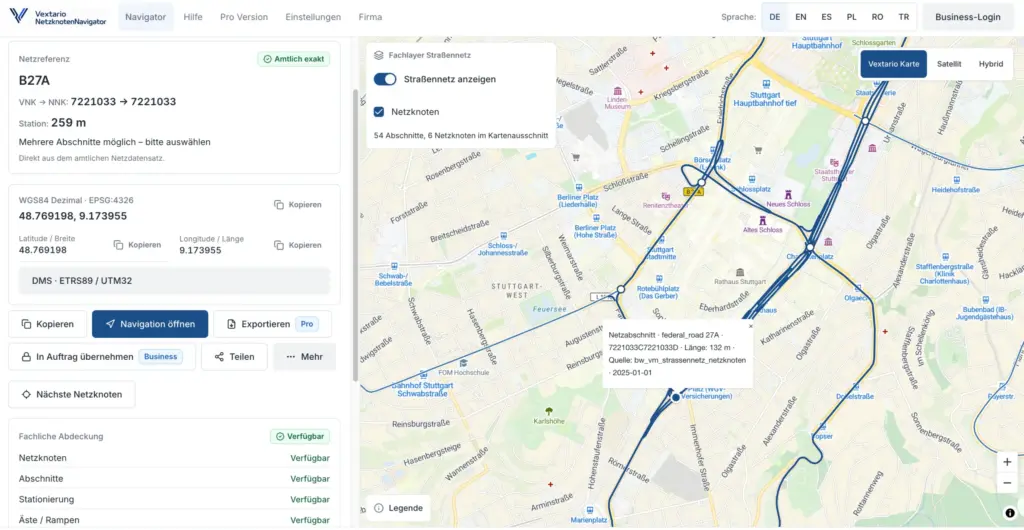
A useful operational record combines the road, section or branch, station, coordinates, and a human-readable location description. Where the work zone is difficult to interpret, the work order should also include a small map showing the highlighted road segment.
This creates several independent ways to detect a mistake before a truck and crew are dispatched.
The network reference identifies the road location according to the road authority’s data structure. Coordinates provide the geographic position. The map allows a visual check. The description helps a person who may never have worked at that location before.
Those layers reinforce one another.
Why is stationing direction so easy to reverse?
Stationing direction is one of the most persistent sources of confusion because crews naturally think in driving directions.
A dispatcher might describe a project as northbound, toward downtown, toward the autobahn, toward Stuttgart, or in the direction of the customer’s site. Those are useful operational descriptions.
Stationing direction is something different.
Within the German road referencing system, the station starts at the beginning of a section and increases along the predefined road direction. That direction does not have to match the direction in which a particular employee is driving at the time.
This creates a very specific failure pattern.
A dispatcher obtains a valid station value from the official network data and then adds an operational direction based on local knowledge. Another employee later assumes that the operational direction is the stationing direction. Beginning and end stations can then be interpreted in reverse.
The best countermeasure is a data-model decision rather than another training memo.
“Stationing direction” and “traffic direction of the work zone” should be separate fields.
The first belongs to the underlying road network reference. The second describes how the work zone, lane closure, traffic flow, or deployment is oriented in operational terms.
Keeping those concepts separate also makes software validation easier. A digital system can maintain the technical stationing reference while presenting the field crew with the directional wording that is useful on site.
Why do ramps and branches create disproportionately difficult cases?
A straightforward road segment between two intersections is relatively easy to visualize. Interchanges, roundabouts, grade-separated junctions, collector-distributor arrangements, and complex access points are different.
This is where branches, or Äste, become important.
A branch is part of the network structure used to represent connections inside a node. To a field employee, however, the same piece of pavement may simply be “the ramp to B 10.”
That difference in perspective matters.
If the actual traffic control operation is located on the ramp while the digital order has been referenced to the through road, both points may appear extremely close in a consumer navigation app. Operationally, however, they are different road objects.
The resulting error can propagate. The wrong network object appears on the work order. The traffic control plan receives the wrong location reference. An inspection route is generated for the mainline instead of the ramp. Photographs are later associated with the wrong section.
One frequent cause is map scale. When a dispatcher is zoomed too far out, separate ramps and mainline segments can visually merge. Selecting the apparently correct line is then surprisingly easy.
A practical countermeasure is to introduce a mandatory detail check whenever several network objects lie close together.
The application should show the selected line, not only a point. It should also show whether the object is a section or branch and require confirmation when an interchange or similarly complex node is involved.
For these locations, automation should become more cautious rather than more aggressive.
How do Netzknoten, zero points, sections, and branches get mixed up?
In everyday conversation, a Netzknoten is often treated as if it were simply a numbered dot on a map. The actual road network model contains additional relationships among network nodes, zero points, sections, and branches.
A field crew does not need to administer that model.
The software does.
Problems appear when an import process captures a node identifier but drops the related section, branch, station, or direction. The database then looks structured because it contains official-looking numbers, while the actual location has become ambiguous.
The same problem occurs in spreadsheets.
A column labeled “Netzknoten” does not define whether the value represents the nearest node, the beginning node, the ending node, or a number that somebody copied from a map. A second employee may use the same field differently without realizing it.
The countermeasure is to model the work-zone location as its own structured object.
Road, section, branch, station, stationing direction, geographic position, source, and data version are stored as separate attributes. The system can then generate a compact description for employees without losing the underlying relationships.
This approach also helps when information is exchanged with another application. Instead of passing around a manually constructed text string, the workflow transfers a defined location record.
How serious are outdated or incomplete network datasets?
Official data does not mean that every public dataset in every German state follows exactly the same publication cycle or includes exactly the same road classes.
Baden-Württemberg provides a useful example. Metadata for one published road network dataset lists 22,056 line features and a source scale of 1:10,000. The same metadata describes event-driven maintenance with updates at least annually. Its current usage restrictions also state that municipal roads are not included and that autobahn sections or branches are presently absent from that particular dataset.
Bavaria illustrates a different publication model. The metadata for its ASB road-network web map service specifies a daily update frequency.
Those are not minor technical details for an application that automatically suggests work-zone locations.
Road networks change. Interchanges are reconstructed. Roundabouts are added. Roads are realigned or reclassified. Administrative responsibilities change. A section may be modified even though an older map still looks perfectly plausible.
The software can therefore perform its own logic correctly and still return an outdated answer if the source data is stale or incomplete.
A robust location record should always retain the data source and data version.
If a field crew discovers that the real road geometry differs from the stored dataset, the application should provide a controlled way to flag the discrepancy. Forcing the employee to choose an outdated but technically valid section only hides the problem.
This principle is particularly important for contractors working across several German states. The same application may need to consume datasets with different structures, publication cycles, licensing terms, and road coverage.
A nationwide workflow requires a data-source layer, not the assumption that every state publishes an identical Netzknoten dataset.
Why can customer descriptions, traffic control plans, and network data point to different places?
Each participant in a project describes a location for a different purpose.
The customer describes the place in language that makes sense from the construction site. The road authority uses its road referencing system. The traffic control planner works from drawings and maps. Dispatch thinks about crew access. A field employee uses a navigation app.
None of those perspectives is inherently wrong.
The difficulty arises when one of them is silently treated as the authoritative replacement for all others.
Consider a request describing “B 27 after the industrial park interchange.” The customer may mean the location as seen from the direction of the construction site. The traffic control drawing may show a precise segment of roadway. A navigation pin may land on the access ramp. An earlier inspection coordinate may be several hundred feet farther along the road.
If the office simply copies the easiest value into every downstream system, the inconsistencies disappear from view but remain in the operation.
A stronger workflow compares them.
The Netzknoten and station provide the road-network reference. The coordinate provides a geographic cross-check. The regulatory documentation and traffic control plan establish the project context. The human-readable description gives the dispatcher and crew a practical orientation.
When those layers disagree, the workflow should stop treating the location as confirmed.
That is a useful exception to automate.
Which Netzknoten error patterns should dispatch and project management check?
| Common error | Typical warning sign | Operational consequence | Immediate countermeasure |
|---|---|---|---|
| Wrong road section | Pin is close to the correct node but on the opposite side | crew reaches the wrong installation or inspection area | verify both bounding nodes and highlighted road segment |
| Reversed stationing direction | station values appear to run “backward” compared with travel | beginning and end of work zone are exchanged | store stationing direction separately from traffic direction |
| Ramp selected instead of mainline | several road lines are very close together | wrong reference in work order or plan | require detailed interchange view and line confirmation |
| Mainline selected instead of branch | work area sits within a complex junction | operation is attached to the wrong network object | explicitly identify section versus branch |
| Outdated network data | field geometry differs from digital network | automatic assignment follows an obsolete road layout | retain source and version and allow a discrepancy flag |
| Conflicting free-text description | order, plan, and navigation use different wording | questions, delays, or wrong arrival point | compare network reference, coordinate, and project documents |
| Wrong parallel carriageway | GPS point sits between nearby road lines | wrong side or direction of divided roadway | visually confirm carriageway before final approval |
The common denominator is worth noting: many location failures do not result from missing information.
They result from several pieces of information that are almost correct.
That is why validation rules are more useful than another large text field labeled “location notes.”
What should a reliable pre-deployment check look like?
A traffic control contractor does not need a full professional GIS workstation at every desk.
The workflow can remain practical.
Before a new location is approved, five elements should agree:
- Road and section or branch.
- Station and stationing direction.
- Geographic coordinates and highlighted road geometry.
- Customer description, traffic control plan, and relevant road-authority documentation.
- Source and version of the network data.
Straightforward locations can pass most of these checks automatically.
Exceptions deserve attention.
If several candidate branches are located around the same interchange, the coordinate is unusually far from the selected line, the station does not fit the geometry, or the customer description points in a different direction, the system should ask the dispatcher to review the location.
Once the record is confirmed, the field crew should not be forced to interpret the entire ASB data model.
Its mobile view can show the map, highlighted roadway, access information, work-zone direction, relevant stations, and documents required for the assignment.
That division of responsibility is important.
Planning and dispatch deal with the underlying network reference. Field crews receive the operational representation they need to perform the job.
What usually goes wrong when locations are copied manually?
Many Netzknoten problems begin in office workflows rather than in road data.
Someone copies an identifier from a PDF into an email. Office staff transfer part of it into an order-management system. Dispatch creates a map screenshot. Another employee later types the location into an inspection sheet.
After several transfers, the organization has several versions of the same place.
Obvious typographical mistakes are often easier to find than subtle semantic errors. If a transposed number moves the location far across a region, somebody notices. If the mistake selects the adjacent section at the same intersection, everything may continue to look reasonable.
That makes manual re-entry particularly dangerous.
A confirmed work-zone location should instead become a reusable digital object.
The work order, traffic control plan, navigation link, inspection record, photographs, and later project history all point to that object. If the network reference needs to be corrected, the location object changes once and downstream processes receive the updated version.
This is a more scalable control for a midsize contractor than attempting to compensate for a fragmented process through increasingly detailed employee instructions.
It also produces a better audit trail. The business can distinguish the original customer location, the system’s proposed match, the confirmed network reference, and any later correction.
How can AI assist with Netzknoten without introducing another source of error?
AI is useful when it reduces search effort and identifies inconsistencies.
Suppose a customer submits a request saying, “B 14, industrial park exit, about 300 meters after the on-ramp.” A system can extract the road number, location name, directional wording, and approximate distance. It can combine those elements with coordinates, previous project data, and road-network geometry to identify likely candidate sections.
That saves a dispatcher from searching several systems manually.
AI can also support validation.
If the submitted coordinate does not fall near the selected road object, if the station is inconsistent with the line geometry, or if several branches are plausible within the same interchange, the application can flag the case.
The dangerous architecture is different.
A model silently guesses the most likely road section and saves the result as if a qualified employee had confirmed it. The same guess is then reused in the traffic control plan, dispatch record, crew navigation, and inspection route.
The error becomes more efficient instead of less likely.
For safety-related operational data, a digital workflow should therefore maintain explicit states such as proposed, checked, confirmed, superseded, or disputed.
AI can make the proposed state faster and better.
It should not erase the distinction between a machine suggestion and an approved operational location.
This is also where a well-designed rules engine can outperform a conversational interface. Many useful checks are deterministic: Is the coordinate near the selected geometry? Does the station fall within the section? Are multiple candidate branches present? Is the dataset version older than the project’s accepted source? Does the work order use a direction that conflicts with the selected carriageway?
AI adds value around those rules by interpreting unstructured requests and explaining unusual cases. It does not need to replace the underlying geospatial logic.
How can a midsize contractor introduce these checks without rebuilding every system?
The most practical starting point is not a nationwide road-data platform.
It is a standard location record.
A company can define which fields are required whenever a work zone is created or approved. Existing order-management software can continue to hold the project itself, while the new location component provides the consistent network reference.
The second step is to remove manual duplication. The same confirmed record should feed the work-order PDF, dispatcher view, mobile field view, navigation link, and inspection workflow.
Only after that foundation works reliably does it make sense to add more advanced automation: automatic candidate search, state-specific data connectors, AI-assisted interpretation of customer requests, conflict detection, route planning, or automated comparison with previous projects.
This sequence matters because sophisticated automation cannot compensate for an undefined source record.
A business that first standardizes the location object gains benefits even before AI is added. Employees search less, corrections are propagated more consistently, and project history becomes easier to reuse.
For companies operating many short-duration work zones, emergency deployments, utility projects, maintenance operations, or frequently changing traffic control setups, those operational gains can become more important than the map feature itself.
Which sources support the quantitative figures used in this article?
LUBW – Road Network, Sections and Branches, SIB metadata
https://rips-metadaten.lubw.de/trefferanzeige?currentSelectorPage=1&docuuid=26ce4af3-4a9a-4259-9450-6606db8529df&f=&rstart=420
Figures used: 22,056 line features, 1:10,000 source scale, and at least annual updating of the described dataset.
LUBW Baden-Württemberg State Institute for the Environment: https://www.lubw.baden-wuerttemberg.de/
GDI-DE – BAYSIS ASB Road Network
https://gdk.gdi-de.org/geonetwork/srv/api/records/ee6d0195-474a-432f-9046-18bd243a7e2c
Figure used: daily update frequency for the described ASB web map service.
Bavarian Road Information System: https://www.baysis.bayern.de/
Which authoritative sources provide useful further reading?
Further reading
Federal Highway Research Institute – Anweisung Straßeninformationsbank
https://www.bast.de/DE/Themen/Digitales/HF_2/Massnahmen/asb.html
Federal Highway Research Institute: https://www.bast.de/
Official background on the German road information database framework and the Netzknoten stationing system.
Straßen.NRW – NWSIB Online
https://www.strassen.nrw.de/de/nwsib-online.html
Straßen.NRW: https://www.strassen.nrw.de/
An operational example of a state road information system supporting searches and road-related technical data.
State of Schleswig-Holstein – Road Information in Schleswig-Holstein
https://opendata.schleswig-holstein.de/dataset/strasseninformationen-in-schleswig-holstein
Schleswig-Holstein Open Data Portal: https://opendata.schleswig-holstein.de/
Official data resource describing section-based road stationing and Netzknoten references.
Frequently asked questions
What is the most common Netzknoten error in traffic control?
A common problem is not selecting a completely unrelated location, but choosing the adjacent section at the correct junction. Because the result remains geographically plausible, the mistake may survive several workflow steps. Checking the section or branch, station, coordinates, and highlighted road geometry together makes this type of error much easier to identify.
How can I identify the correct stationing direction?
Stationing direction comes from the predefined direction of the road referencing system and should be obtained from the underlying road data. It does not automatically match the direction in which a crew is traveling. A work order should therefore keep technical stationing direction separate from the operational traffic direction used by dispatchers and field employees.
Are GPS coordinates enough to define a work-zone location?
Coordinates are extremely useful but are not always sufficient as the sole road-network reference. At interchanges, divided highways, ramps, frontage roads, and closely parallel roadways, several network objects may exist within a small geographic area. Combining coordinates with the section, branch, station, and stationing direction provides a more reliable operational record.
What deserves special attention at ramps and interchanges?
The selected road geometry should be inspected at a detailed scale rather than relying only on a point marker. The system should identify whether the object is a mainline section or a branch and display the complete selected line. Where several plausible objects exist, a dispatcher should confirm the final assignment before it reaches downstream documents.
Why can official road-network data differ from conditions in the field?
Road networks evolve through reconstruction, new junctions, realignments, reclassification, and changes in administrative responsibility. Public datasets also have different update cycles and coverage. Storing the data source and version with the location allows a contractor to recognize these differences and document a field discrepancy instead of forcing an obsolete reference into the project record.
What information belongs in a digital work-zone location record?
A practical record should include the road, section or branch, station, stationing direction, geographic coordinates, network-data source, and data version. A human-readable description and map preview are also valuable. Traffic control plans, regulatory documents, navigation, inspections, and photographs should reference that shared location rather than creating independent location descriptions.
Should field crews manually type Netzknoten identifiers?
Manual entry should generally be minimized. Planning or dispatch can select and approve the underlying network reference, while crews receive a visual and operational representation on their mobile devices. When a correction is needed in the field, map-based selection or a controlled candidate list is usually less error-prone than typing complex identifiers on a phone.
What should happen when the work order and network data identify different places?
The workflow should treat the location as unresolved rather than silently choosing one source. Coordinates, road geometry, customer description, traffic control plan, and network reference should be compared. Once the location is confirmed, the corrected record should propagate to dispatch, navigation, installation documentation, and later inspections so that competing versions do not remain in circulation.
Can AI automatically determine the correct Netzknoten?
AI can interpret customer descriptions and combine them with coordinates, road numbers, maps, and structured network data to propose likely sections. That can substantially reduce manual search work. Complex interchanges, multiple nearby branches, conflicting inputs, or safety-relevant uncertainty should still trigger a review before the proposed network reference becomes the approved operational location.
How can a contractor prevent a corrected Netzknoten error from returning later?
The confirmed location should be maintained as a central, versioned object referenced by work orders, traffic control plans, navigation, inspections, and project documentation. When the section or station is corrected, the change is made once. This prevents old and new location variants from continuing independently in spreadsheets, PDFs, messages, and field records.
